


6759
460
947
 Français
Français
Français  English (AI)
  Deutsch (AI)
  Français
 English (AI) Deutsch (AI)
Français
Français English (AI) Deutsch (AI)
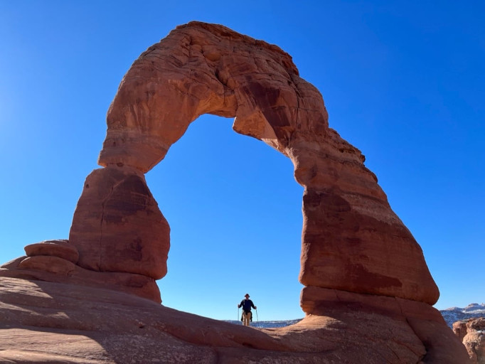
| Nom original | Delicate Arch |
| Pays | États-Unis |
| Latitude | 38.743600 ▶ 38° 44′ 36.96″ N |
| Longitude | -109.499300 ▶ 109° 29′ 57.48″ W |
| Description | traduction/geologie/usa-delicate-arch_fr.php |
| Lien Google images | https://www.google.com/search?q=Delicate+Arch&tbm=isch |
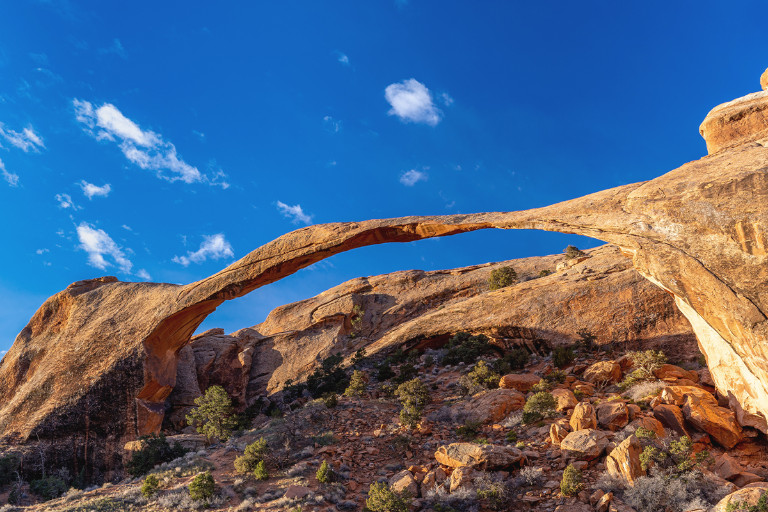
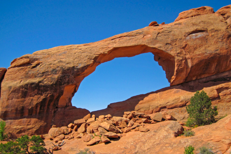
| Nom original | Landscape Arch |
| Pays | États-Unis |
| Latitude | 38.790700 ▶ 38° 47′ 26.52″ N |
| Longitude | -109.607400 ▶ 109° 36′ 26.64″ W |
| Description | traduction/geologie/usa-landscape-arch_fr.php |
| Lien Google images | https://www.google.com/search?q=Landscape+Arch&tbm=isch |
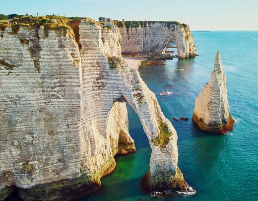
| Nom original | Les Falaises d'Étretat |
| Pays | France |
| Latitude | 49.707100 ▶ 49° 42′ 25.56″ N |
| Longitude | 0.201600 ▶ 0° 12′ 5.76″ E |
| Description | traduction/geologie/fra-falaises-etretat_fr.php |
| Lien Google images | https://www.google.com/search?q=Falaises+Etretat&tbm=isch |
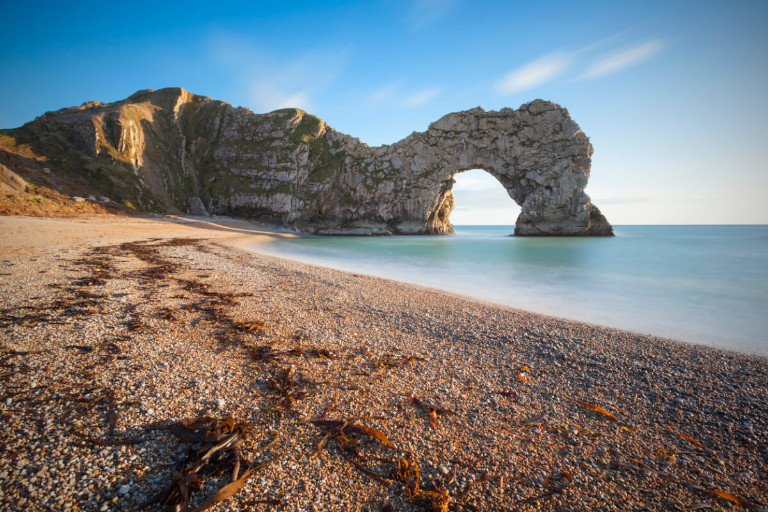
| Nom original | Durdle Door |
| Pays | Royaume-Uni |
| Latitude | 50.621200 ▶ 50° 37′ 16.32″ N |
| Longitude | -2.276600 ▶ 2° 16′ 35.76″ W |
| Description | traduction/geologie/gbr-durdle-door_fr.php |
| Lien Google images | https://www.google.com/search?q=Durdle+Door&tbm=isch |
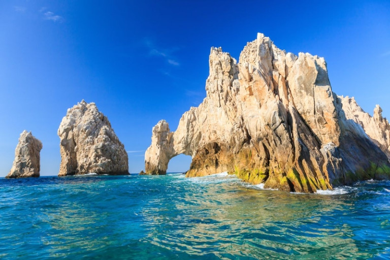
| Nom original | El Arco de Cabo San Lucas |
| Pays | Mexique |
| Latitude | 22.875800 ▶ 22° 52′ 32.88″ N |
| Longitude | -109.894400 ▶ 109° 53′ 39.84″ W |
| Description | traduction/geologie/mex-arche-cabo-san-lucas_fr.php |
| Lien Google images | https://www.google.com/search?q=El+Arco+de+Cabo+San+Lucas&tbm=isch |
| Nom original | Tushuk Tash |
| Pays | Chine |
| Latitude | 39.660800 ▶ 39° 39′ 38.88″ N |
| Longitude | 75.523900 ▶ 75° 31′ 26.04″ E |
| Description | traduction/geologie/chn-arche-shipton_fr.php |
| Lien Google images | https://www.google.com/search?q=Shipton's+Arch+Tushuk+Tash&tbm=isch |
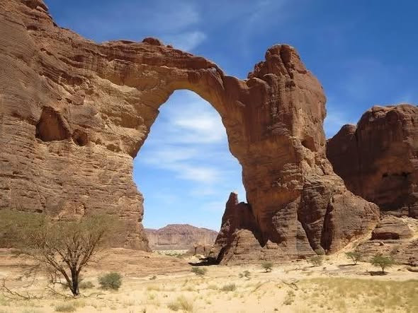
| Nom original | Oued Aloba |
| Pays | Tchad |
| Latitude | 17.151700 ▶ 17° 9′ 6.12″ N |
| Longitude | 21.319700 ▶ 21° 19′ 10.92″ E |
| Description | traduction/geologie/tcd-arche-aloba_fr.php |
| Lien Google images | https://www.google.com/search?q=Arche+d'Aloba+Chad&tbm=isch |
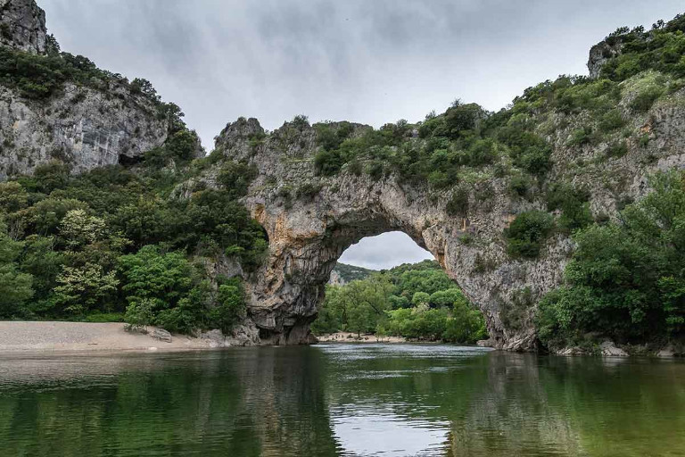
| Nom original | Le Pont d'Arc |
| Pays | France |
| Latitude | 44.382100 ▶ 44° 22′ 55.56″ N |
| Longitude | 4.416800 ▶ 4° 25′ 0.48″ E |
| Description | traduction/geologie/fra-pont-arc_fr.php |
| Lien Google images | https://www.google.com/search?q=Le+Pont+d'Arc+Ardeche&tbm=isch |
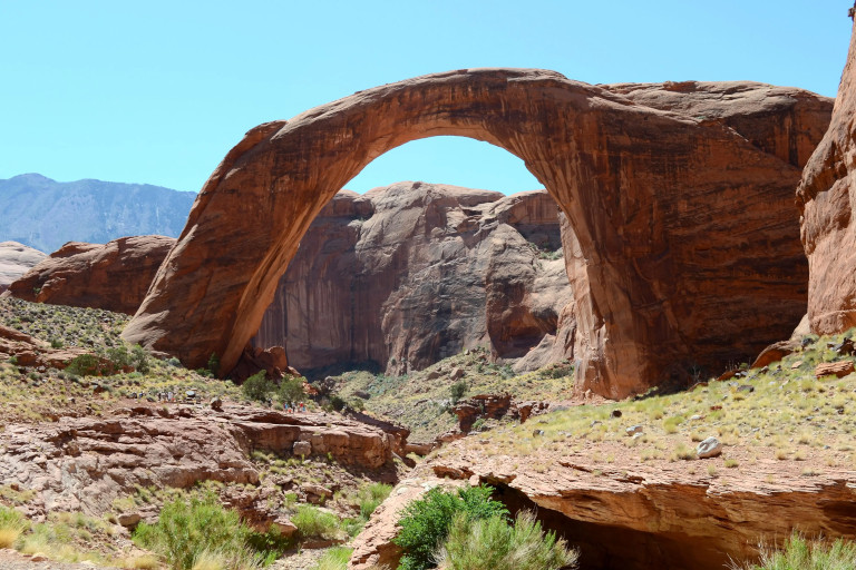
| Nom original | Rainbow Bridge National Monument |
| Pays | États-Unis |
| Latitude | 37.077500 ▶ 37° 4′ 39.00″ N |
| Longitude | -110.964200 ▶ 110° 57′ 51.12″ W |
| Description | traduction/geologie/usa-rainbow-bridge_fr.php |
| Lien Google images | https://www.google.com/search?q=Rainbow+Bridge+National+Monument&tbm=isch |
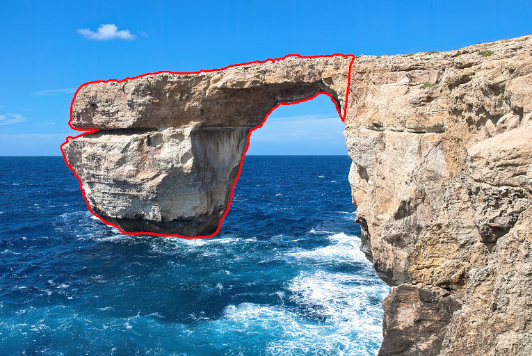
| Nom original | it-Tieqa tad-Dwejra |
| Pays | Malte |
| Latitude | 36.053600 ▶ 36° 3′ 12.96″ N |
| Longitude | 14.188300 ▶ 14° 11′ 17.88″ E |
| Description | traduction/geologie/mlt-fenetre-azur_fr.php |
| Lien Google images | https://www.google.com/search?q=Azure+Window+Malta&tbm=isch |
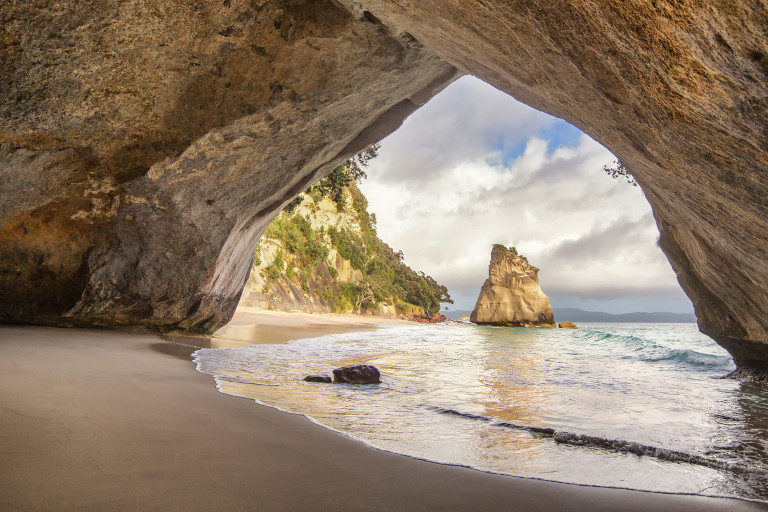
| Nom original | Te Whanganui-A-Hei |
| Pays | Nouvelle-Zélande |
| Latitude | -36.828400 ▶ 36° 49′ 42.24″ S |
| Longitude | 175.790700 ▶ 175° 47′ 26.52″ E |
| Description | traduction/geologie/nzl-cathedral-cove_fr.php |
| Lien Google images | https://www.google.com/search?q=Cathedral+Cove+New+Zealand&tbm=isch |
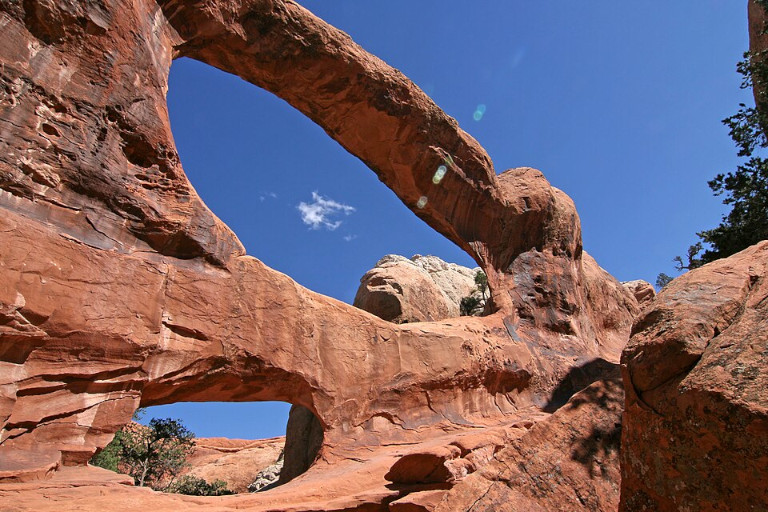
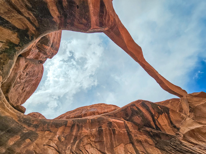
| Nom original | Double O Arch |
| Pays | États-Unis |
| Latitude | 38.799200 ▶ 38° 47′ 57.12″ N |
| Longitude | -109.625600 ▶ 109° 37′ 32.16″ W |
| Description | traduction/geologie/usa-arche-double-o_fr.php |
| Lien Google images | https://www.google.com/search?q=Double+O+Arch+Arches+National+Park&tbm=isch |
| Nom original | Tower Arch |
| Pays | États-Unis |
| Latitude | 38.789200 ▶ 38° 47′ 21.12″ N |
| Longitude | -109.686900 ▶ 109° 41′ 12.84″ W |
| Description | traduction/geologie/usa-arche-tour_fr.php |
| Lien Google images | https://www.google.com/search?q=Tower+Arch+Arches+National+Park&tbm=isch |
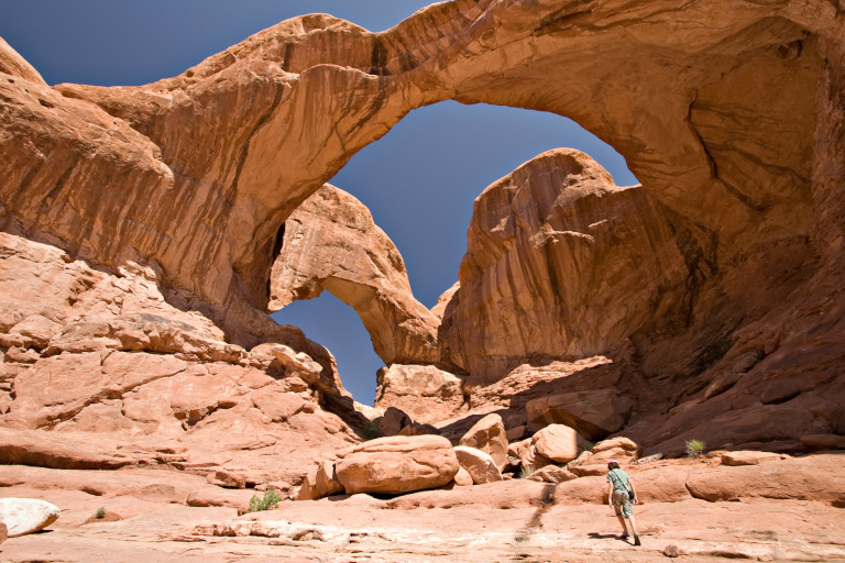
| Nom original | Double Arch |
| Pays | États-Unis |
| Latitude | 38.691400 ▶ 38° 41′ 29.04″ N |
| Longitude | -109.532800 ▶ 109° 31′ 58.08″ W |
| Description | traduction/geologie/usa-arche-double_fr.php |
| Lien Google images | https://www.google.com/search?q=Double+Arch+Arches+National+Park&tbm=isch |
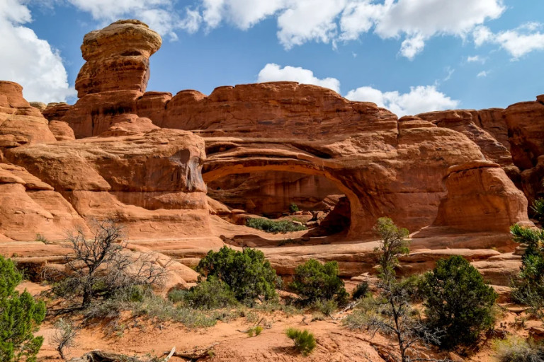
| Nom original | Ring Arch |
| Pays | États-Unis |
| Latitude | 38.692500 ▶ 38° 41′ 33.00″ N |
| Longitude | -109.479400 ▶ 109° 28′ 45.84″ W |
| Description | traduction/geologie/usa-arche-anneau_fr.php |
| Lien Google images | https://www.google.com/search?q=Ring+Arch+Arches+National+Park&tbm=isch |
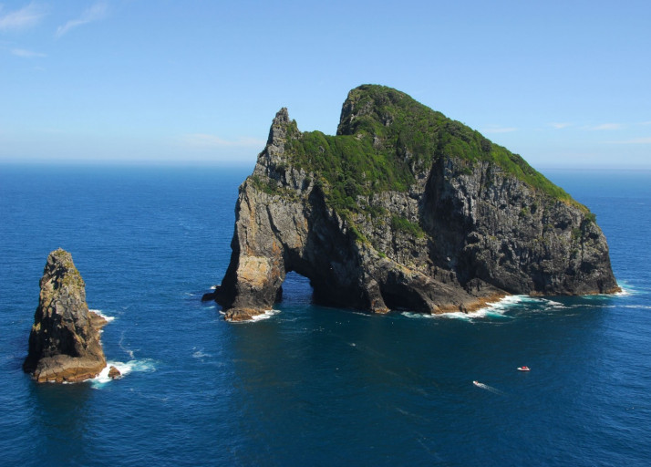
| Nom original | Motukokako |
| Pays | Nouvelle-Zélande |
| Latitude | -35.170600 ▶ 35° 10′ 14.16″ S |
| Longitude | 174.337500 ▶ 174° 20′ 15.00″ E |
| Description | traduction/geologie/nzl-trou-dans-rocher_fr.php |
| Lien Google images | https://www.google.com/search?q=Piercy+Island+Hole+in+the+Rock&tbm=isch |
| Nom original | Skyline Arch |
| Pays | États-Unis |
| Latitude | 38.790500 ▶ 38° 47′ 25.80″ N |
| Longitude | -109.601400 ▶ 109° 36′ 5.04″ W |
| Description | traduction/geologie/usa-arche-skyline_fr.php |
| Lien Google images | https://www.google.com/search?q=Skyline+Arch+Arches+National+Park&tbm=isch |
| Nom original | Sand Dune Arch |
| Pays | États-Unis |
| Latitude | 38.764700 ▶ 38° 45′ 52.92″ N |
| Longitude | -109.583600 ▶ 109° 35′ 0.96″ W |
| Description | traduction/geologie/usa-arche-dune-sable_fr.php |
| Lien Google images | https://www.google.com/search?q=Sand+Dune+Arch+Arches+National+Park&tbm=isch |
| Nom original | Gora Koltso |
| Pays | Russie |
| Latitude | 43.940600 ▶ 43° 56′ 26.16″ N |
| Longitude | 42.693600 ▶ 42° 41′ 36.96″ E |
| Description | traduction/geologie/_fr.php |
| Lien Google images | https://www.google.com/search?q=Ring+Mountain+Kislovodsk&tbm=isch |
| Nom original | Um Frouth |
| Pays | Jordanie |
| Latitude | 29.574200 ▶ 29° 34′ 27.12″ N |
| Longitude | 35.441900 ▶ 35° 26′ 30.84″ E |
| Description | traduction/geologie/_fr.php |
| Lien Google images | https://www.google.com/search?q=Um+Frouth+Rock+Bridge&tbm=isch |
| Nom original | Burdah |
| Pays | Jordanie |
| Latitude | 29.623900 ▶ 29° 37′ 26.04″ N |
| Longitude | 35.463600 ▶ 35° 27′ 48.96″ E |
| Description | traduction/geologie/_fr.php |
| Lien Google images | https://www.google.com/search?q=Burdah+Rock+Bridge&tbm=isch |
| Nom original | Little Bridge |
| Pays | Jordanie |
| Latitude | 29.589400 ▶ 29° 35′ 21.84″ N |
| Longitude | 35.426100 ▶ 35° 25′ 33.96″ E |
| Description | traduction/geologie/_fr.php |
| Lien Google images | https://www.google.com/search?q=Little+Bridge+Wadi+Rum&tbm=isch |
| Nom original | Kharazeh |
| Pays | Jordanie |
| Latitude | 29.743100 ▶ 29° 44′ 35.16″ N |
| Longitude | 35.535800 ▶ 35° 32′ 8.88″ E |
| Description | traduction/geologie/_fr.php |
| Lien Google images | https://www.google.com/search?q=Kharazeh+Arch+Wadi+Rum&tbm=isch |
| Nom original | Apostle Islands |
| Pays | États-Unis |
| Latitude | 46.940000 ▶ 46° 56′ 24.00″ N |
| Longitude | -90.580000 ▶ 90° 34′ 48.00″ W |
| Description | traduction/geologie/_fr.php |
| Lien Google images | https://www.google.com/search?q=Apostle+Islands+Sea+Caves&tbm=isch |
| Nom original | Praia das Catedrais |
| Pays | Espagne |
| Latitude | 43.553900 ▶ 43° 33′ 14.04″ N |
| Longitude | -7.155800 ▶ 7° 9′ 20.88″ W |
| Description | traduction/geologie/_fr.php |
| Lien Google images | https://www.google.com/search?q=Playa+de+las+Catedrales+Galicia&tbm=isch |
| Nom original | Yesnaby Castle |
| Pays | Royaume-Uni |
| Latitude | 59.027000 ▶ 59° 1′ 37.20″ N |
| Longitude | -3.359000 ▶ 3° 21′ 32.40″ W |
| Description | traduction/geologie/_fr.php |
| Lien Google images | https://www.google.com/search?q=Yesnaby+Castle+Orkney&tbm=isch |
| Nom original | Elephant Rock |
| Pays | Tchad |
| Latitude | 16.920500 ▶ 16° 55′ 13.80″ N |
| Longitude | 21.603300 ▶ 21° 36′ 11.88″ E |
| Description | traduction/geologie/_fr.php |
| Lien Google images | https://www.google.com/search?q=Elephant+Arch+Ennedi+Chad&tbm=isch |
| Nom original | Julia Arch |
| Pays | Tchad |
| Latitude | 16.897200 ▶ 16° 53′ 49.92″ N |
| Longitude | 21.503600 ▶ 21° 30′ 12.96″ E |
| Description | traduction/geologie/_fr.php |
| Lien Google images | https://www.google.com/search?q=Julia+Arch+Ennedi+Chad&tbm=isch |
| Nom original | The Five Arches |
| Pays | Tchad |
| Latitude | 17.042500 ▶ 17° 2′ 33.00″ N |
| Longitude | 21.688300 ▶ 21° 41′ 17.88″ E |
| Description | traduction/geologie/_fr.php |
| Lien Google images | https://www.google.com/search?q=Five+Arches+Ennedi+Chad&tbm=isch |
| Nom original | Deli Arch |
| Pays | Tchad |
| Latitude | 16.816700 ▶ 16° 49′ 0.12″ N |
| Longitude | 21.816700 ▶ 21° 49′ 0.12″ E |
| Description | traduction/geologie/_fr.php |
| Lien Google images | https://www.google.com/search?q=Deli+Arch+Ennedi+Chad&tbm=isch |
| Nom original | Toukoul Arch |
| Pays | Tchad |
| Latitude | 17.100000 ▶ 17° 6′ 0.00″ N |
| Longitude | 21.450000 ▶ 21° 26′ 60.00″ E |
| Description | traduction/geologie/_fr.php |
| Lien Google images | https://www.google.com/search?q=Toukoul+Arch+Ennedi+Chad&tbm=isch |
| Nom original | Xianren Qiao |
| Pays | Chine |
| Latitude | 24.686000 ▶ 24° 41′ 9.60″ N |
| Longitude | 106.632000 ▶ 106° 37′ 55.20″ E |
| Description | traduction/geologie/_fr.php |
| Lien Google images | https://www.google.com/search?q=Xianren+Bridge+Fairy+Bridge+China&tbm=isch |
| Nom original | Jiangzhou Immortal Bridge |
| Pays | Chine |
| Latitude | 24.110000 ▶ 24° 6′ 36.00″ N |
| Longitude | 107.410000 ▶ 107° 24′ 36.00″ E |
| Description | traduction/geologie/_fr.php |
| Lien Google images | https://www.google.com/search?q=Jiangzhou+Immortal+Bridge&tbm=isch |
| Nom original | Kolob Arch |
| Pays | États-Unis |
| Latitude | 37.420000 ▶ 37° 25′ 12.00″ N |
| Longitude | -113.155000 ▶ 113° 9′ 18.00″ W |
| Description | traduction/geologie/_fr.php |
| Lien Google images | https://www.google.com/search?q=Kolob+Arch+Zion&tbm=isch |
| Nom original | Morning Glory Natural Bridge |
| Pays | États-Unis |
| Latitude | 38.586000 ▶ 38° 35′ 9.60″ N |
| Longitude | -109.475000 ▶ 109° 28′ 30.00″ W |
| Description | traduction/geologie/_fr.php |
| Lien Google images | https://www.google.com/search?q=Morning+Glory+Natural+Bridge+Moab&tbm=isch |
| Nom original | Gaotun Tiansheng Qiao |
| Pays | Chine |
| Latitude | 26.746000 ▶ 26° 44′ 45.60″ N |
| Longitude | 109.324000 ▶ 109° 19′ 26.40″ E |
| Description | traduction/geologie/_fr.php |
| Lien Google images | https://www.google.com/search?q=Gaotun+Natural+Bridge+China&tbm=isch |
| Nom original | Sipapu Natural Bridge |
| Pays | États-Unis |
| Latitude | 37.617000 ▶ 37° 37′ 1.20″ N |
| Longitude | -110.015000 ▶ 110° 0′ 54.00″ W |
| Description | traduction/geologie/_fr.php |
| Lien Google images | https://www.google.com/search?q=Sipapu+Natural+Bridge&tbm=isch |
| Nom original | Stevens Arch |
| Pays | États-Unis |
| Latitude | 37.433000 ▶ 37° 25′ 58.80″ N |
| Longitude | -110.981000 ▶ 110° 58′ 51.60″ W |
| Description | traduction/geologie/_fr.php |
| Lien Google images | https://www.google.com/search?q=Stevens+Arch+Escalante&tbm=isch |