


6759
460
947
 Français
Français
Français  English (AI)
  Deutsch (AI)
  Français
 English (AI) Deutsch (AI)
Français
Français English (AI) Deutsch (AI)
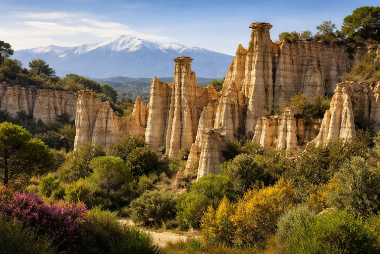
| Nom original | Orgues d'Ille-sur-Têt |
| Pays | France |
| Latitude | 42.681944 ▶ 42° 40′ 55.00″ N |
| Longitude | 2.624722 ▶ 2° 37′ 29.00″ E |
| Description | traduction/geologie/fra-orgues-ille-sur-tet_fr.php |
| Lien Google images | https://www.google.com/search?q=Orgues+d'Ille-sur-Têt&tbm=isch |
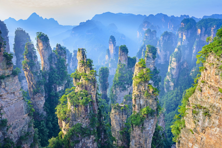
| Nom original | Wulingyuan |
| Pays | Chine |
| Latitude | 29.314200 ▶ 29° 18′ 51.12″ N |
| Longitude | 110.435000 ▶ 110° 26′ 6.00″ E |
| Description | traduction/geologie/chn-zhangjiajie_fr.php |
| Lien Google images | https://www.google.com/search?q=Zhangjiajie+National+Forest+Park&tbm=isch |
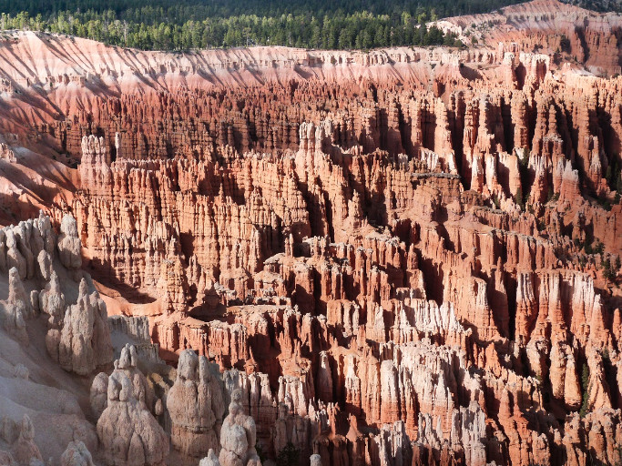
| Nom original | Bryce Canyon |
| Pays | États-Unis |
| Latitude | 37.628300 ▶ 37° 37′ 41.88″ N |
| Longitude | -112.167700 ▶ 112° 10′ 3.72″ W |
| Description | traduction/geologie/usa-bryce-canyon_fr.php |
| Lien Google images | https://www.google.com/search?q=Bryce+Canyon+hoodoos&tbm=isch |
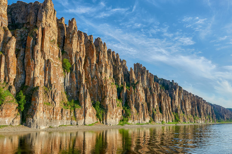
| Nom original | Lenskiye Stolby |
| Pays | Russie |
| Latitude | 61.127500 ▶ 61° 7′ 39.00″ N |
| Longitude | 127.352200 ▶ 127° 21′ 7.92″ E |
| Description | traduction/geologie/rus-piliers-de-la-lena_fr.php |
| Lien Google images | https://www.google.com/search?q=Lena+Pillars+Russia&tbm=isch |
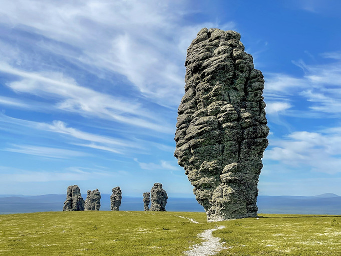
| Nom original | Manpupuner |
| Pays | Russie |
| Latitude | 62.204400 ▶ 62° 12′ 15.84″ N |
| Longitude | 59.295800 ▶ 59° 17′ 44.88″ E |
| Description | traduction/geologie/rus-manpupuner_fr.php |
| Lien Google images | https://www.google.com/search?q=Manpupuner+rock+formations&tbm=isch |
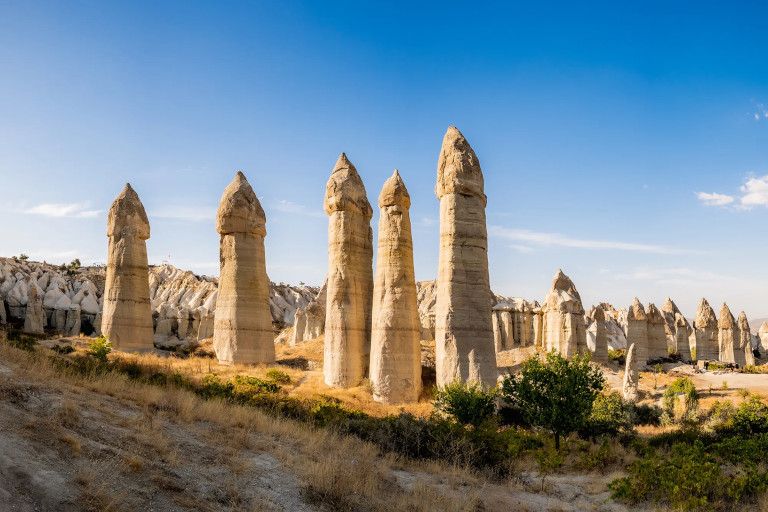
| Nom original | Peri Bacaları |
| Pays | Turquie |
| Latitude | 38.649800 ▶ 38° 38′ 59.28″ N |
| Longitude | 34.853000 ▶ 34° 51′ 10.80″ E |
| Description | traduction/geologie/tur-cheminee-de-cappadoce_fr.php |
| Lien Google images | https://www.google.com/search?q=Cappadocia+fairy+chimneys&tbm=isch |
| Nom original | Đavolja Varoš |
| Pays | Serbie |
| Latitude | 42.988100 ▶ 42° 59′ 17.16″ N |
| Longitude | 21.403600 ▶ 21° 24′ 12.96″ E |
| Description | traduction/geologie/_fr.php |
| Lien Google images | https://www.google.com/search?q=Djavolja+Varos&tbm=isch |
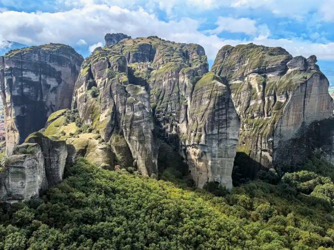
| Nom original | Metéora |
| Pays | Grèce |
| Latitude | 39.721700 ▶ 39° 43′ 18.12″ N |
| Longitude | 21.630600 ▶ 21° 37′ 50.16″ E |
| Description | traduction/geologie/grc-meteores_fr.php |
| Lien Google images | https://www.google.com/search?q=Meteora+Greece&tbm=isch |
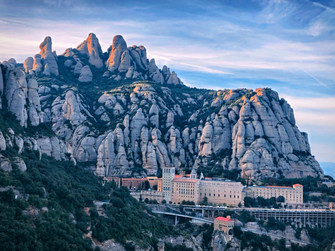
| Nom original | Montserrat |
| Pays | Espagne |
| Latitude | 41.593300 ▶ 41° 35′ 35.88″ N |
| Longitude | 1.837200 ▶ 1° 50′ 13.92″ E |
| Description | traduction/geologie/esp-montserrat_fr.php |
| Lien Google images | https://www.google.com/search?q=Montserrat+Mountain+Spain&tbm=isch |
| Nom original | The Pinnacles |
| Pays | Australie |
| Latitude | -30.602800 ▶ 30° 36′ 10.08″ S |
| Longitude | 115.157800 ▶ 115° 9′ 28.08″ E |
| Description | traduction/geologie/_fr.php |
| Lien Google images | https://www.google.com/search?q=The+Pinnacles+Nambung+Desert&tbm=isch |
| Nom original | Valle de las Ánimas |
| Pays | Bolivie (État plurinational de) |
| Latitude | -16.516100 ▶ 16° 30′ 57.96″ S |
| Longitude | -67.994400 ▶ 67° 59′ 39.84″ W |
| Description | traduction/geologie/_fr.php |
| Lien Google images | https://www.google.com/search?q=Valle+de+las+Animas+Bolivia&tbm=isch |
| Nom original | The Phallus |
| Pays | États-Unis |
| Latitude | 38.777200 ▶ 38° 46′ 37.92″ N |
| Longitude | -109.593900 ▶ 109° 35′ 38.04″ W |
| Description | traduction/geologie/usa-phallus_fr.php |
| Lien Google images | https://www.google.com/search?q=The+Phallus+Arches+National+Park&tbm=isch |
| Nom original | Belyye Skaly |
| Pays | Russie |
| Latitude | 45.319400 ▶ 45° 19′ 9.84″ N |
| Longitude | 148.016700 ▶ 148° 1′ 0.12″ E |
| Description | traduction/geologie/_fr.php |
| Lien Google images | https://www.google.com/search?q=Belyye+Skaly+Iturup&tbm=isch |
| Nom original | Stolby |
| Pays | Russie |
| Latitude | 55.912500 ▶ 55° 54′ 45.00″ N |
| Longitude | 92.730800 ▶ 92° 43′ 50.88″ E |
| Description | traduction/geologie/_fr.php |
| Lien Google images | https://www.google.com/search?q=Krasnoyarsk+Pillars&tbm=isch |
| Nom original | Kutkhiny Baty |
| Pays | Russie |
| Latitude | 51.464200 ▶ 51° 27′ 51.12″ N |
| Longitude | 157.062200 ▶ 157° 3′ 43.92″ E |
| Description | traduction/geologie/_fr.php |
| Lien Google images | https://www.google.com/search?q=Kutkhiny+Baty+Kamchatka&tbm=isch |
| Nom original | Ak-Kurum |
| Pays | Russie |
| Latitude | 51.111100 ▶ 51° 6′ 39.96″ N |
| Longitude | 87.972200 ▶ 87° 58′ 19.92″ E |
| Description | traduction/geologie/_fr.php |
| Lien Google images | https://www.google.com/search?q=Altai+stone+mushrooms&tbm=isch |
| Nom original | Rock Mushroom |
| Pays | Jordanie |
| Latitude | 29.605000 ▶ 29° 36′ 18.00″ N |
| Longitude | 35.405000 ▶ 35° 24′ 18.00″ E |
| Description | traduction/geologie/_fr.php |
| Lien Google images | https://www.google.com/search?q=Mushroom+Rock+Wadi+Rum&tbm=isch |
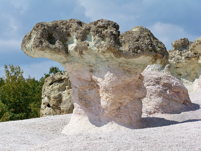
| Nom original | Kamenni Gabi |
| Pays | Bulgarie |
| Latitude | 41.748300 ▶ 41° 44′ 53.88″ N |
| Longitude | 25.432800 ▶ 25° 25′ 58.08″ E |
| Description | traduction/geologie/bgr-champignons-beli-plast_fr.php |
| Lien Google images | https://www.google.com/search?q=Stone+Mushrooms+Beli+Plast&tbm=isch |
| Nom original | Le Champignon |
| Pays | France |
| Latitude | 45.347500 ▶ 45° 20′ 51.00″ N |
| Longitude | 0.536400 ▶ 0° 32′ 11.04″ E |
| Description | traduction/geologie/_fr.php |
| Lien Google images | https://www.google.com/search?q=Le+Champignon+Paussac+et+Saint+Vivien&tbm=isch |
| Nom original | Ennedi Mushroom |
| Pays | Tchad |
| Latitude | 17.025000 ▶ 17° 1′ 30.00″ N |
| Longitude | 21.785000 ▶ 21° 47′ 6.00″ E |
| Description | traduction/geologie/_fr.php |
| Lien Google images | https://www.google.com/search?q=Ennedi+Mushroom+Rock+Chad&tbm=isch |
| Nom original | Goblin Valley |
| Pays | États-Unis |
| Latitude | 38.565300 ▶ 38° 33′ 55.08″ N |
| Longitude | -110.702200 ▶ 110° 42′ 7.92″ W |
| Description | traduction/geologie/_fr.php |
| Lien Google images | https://www.google.com/search?q=Goblin+Valley+State+Park&tbm=isch |
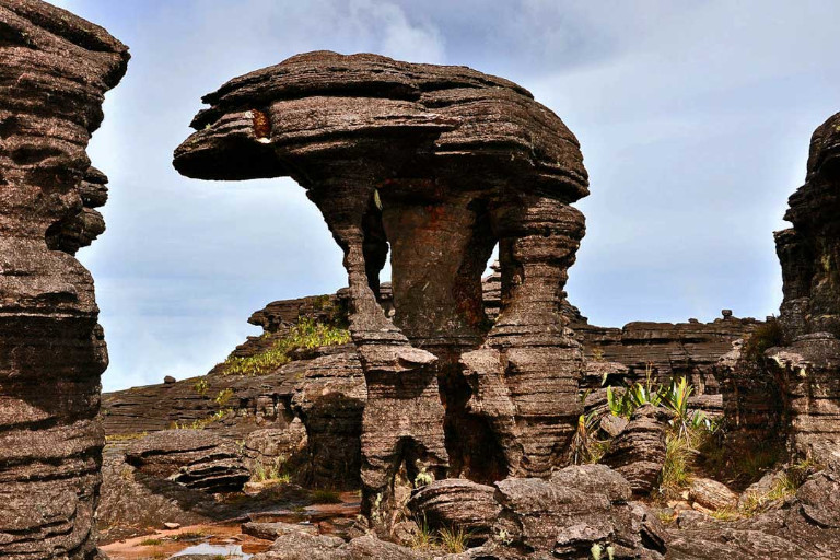
| Nom original | Roraima Mushroom |
| Pays | Venezuela |
| Latitude | 5.235000 ▶ 5° 14′ 6.00″ N |
| Longitude | -60.762000 ▶ 60° 45′ 43.20″ W |
| Description | traduction/geologie/ven-champignon-roraima_fr.php |
| Lien Google images | https://www.google.com/search?q=Mushroom+Rock+Mount+Roraima&tbm=isch |